Global warming and tropical cyclones
A treat in store for the climate sceptics. I hope their beach homes are well insured (or do I?) ...
Last week I talked about one downside of accepting global warming. Here’s another.
When I joined the staff at the University of the South Pacific (Suva, Fiji) in 1977, I didn’t know much atmospheric physics. Only what I’d learnt as an undergraduate at the University of Canterbury as few years earlier. I now know that I should have been concerned about the high levels of UV my family would be exposed to there in the tropics. Suva’s latitude is 18 S. According to the GlobalUV smartphone app, in summer the clear-sky UVI there is about 15 and can exceed 11 for two hours either side of noon (when it’s not raining!) Even in the middle of winter the noon value can exceed 7. But instead of concerning myself about that, I was becoming more interested in tropical cyclones.
Along with the mosquito-borne dengue fever that thrives in the humid tropical climate, tropical cyclones are the bane of life in Fiji. Their importance would hit home when Fiji, including Suva, was devastated by direct-hit from Cyclone Meli towards the end of our time there in 1979. To this day it remains the deadliest storm ever to hit Fiji, with 55 lives lost.
Even before that, tropical cyclones were an important topic for the region, and forecasting their paths could save lives. I embarked on a study, under the supervision of Roger Nisbet, to see whether their paths could be affected by variations in the underlying sea surface temperature. It was known that temperatures greater than 26 C were needed to spawn them in the first place, and satellite-derived sea surface temperatures were just becoming available. Perhaps that new knowledge could save lives?
My idea was a bit naive, but it taught me a lot. In reality, their paths are driven by variations in atmospheric pressure - weather systems. I found little evidence for them being driven by sea surface temperature fields, but no doubt their strength would be amplified over warmer waters. If you want to know more about the study, results can be found here.
It’s only when the surface temperatures exceed 26 C that there’s enough water vapour entrained in the uplifted air to sustain their development. As air is drawn upwards inside the core, the water vapour (a gas) condenses to liquid form (rain), and that change-of-state from liquid to gas releases the huge amounts of energy needed to warm the air enough to retain its buoyancy and continue its rise, so forming the towering clouds that sometimes exceed 15 km in altitude. That’s why tropical cyclones always start to peter out after they cross the ocean-to-land boundary.
Tropical cyclones are big beasts, sometimes exceeding 500 km in diameter. The other thing needed to sustain them is something to induce a spin. That’s caused the deflection of wind direction as a parcel of air moves across latitude bands. It’s called a Coriolis deflection and is induced by the spin of the Earth on its axis. Since all points are rotating at the same angular speed (one revolution every 24 hours), points on the equator are moving faster than at lower latitudes. For example, under calm conditions air at the equator (and the land underneath it) is moving east at the staggering rate of 1668 km/hr. You don’t notice it because of frictional forces that mean the atmosphere rotates at the same speed as the land - apart from deviations caused by weather systems.
A bit of simple maths that you can skip if you like. The speed of any point on the surface of a rotating sphere of radius R, at angle L from a line perpendicular its spin axis, is the distance travelled (2*pi*R*cos(L)) divided by the time taken for a full rotation (T). For planet Earth, with radius 6371 km rotating once every 24 hours, that’s 1668 * cos(L), where L is the latitude. That comes to 1668 km/hr at the equator (latitude 0), reducing progressively at higher latitudes. At latitudes 10, 20, 30, and 40 degrees the speeds reduce to 1643, 1567, 1445, and 1278 km/hour respectively (collapsing to 0 km/hour at the north and south poles).
By the time a a parcel of air moving directly away from the equator gets to latitude 10 degrees, a travel-distance of about 1000 km, it would have an additional easterly component to its speed (relative to the underlying surface) of about 25 km/hr (1668 - 1643). It turns out that such a ‘small’ deflection is usually insufficient to provide the twist needed to sustain the cyclone vortex, which is why tropical cyclones don’t form over the equator. They usually form only at latitudes greater than 5 degrees latitudes where those changes in speed with latitude become large enough for sufficient twist to be exerted. For example, going from latitude 10 to 20, the difference in speed increases to 76 km/hour (3 times more than from 0 to 10 degrees), from latitude 20 to 30 it is 122 km/hour (5 times more), and from latitude 30 to 40 it is 167 km/hour (nearly 7 times more). As you can see from those figures, the Coriolis deflection, which controls the strength of tropical cyclones increases rapidly with latitude.
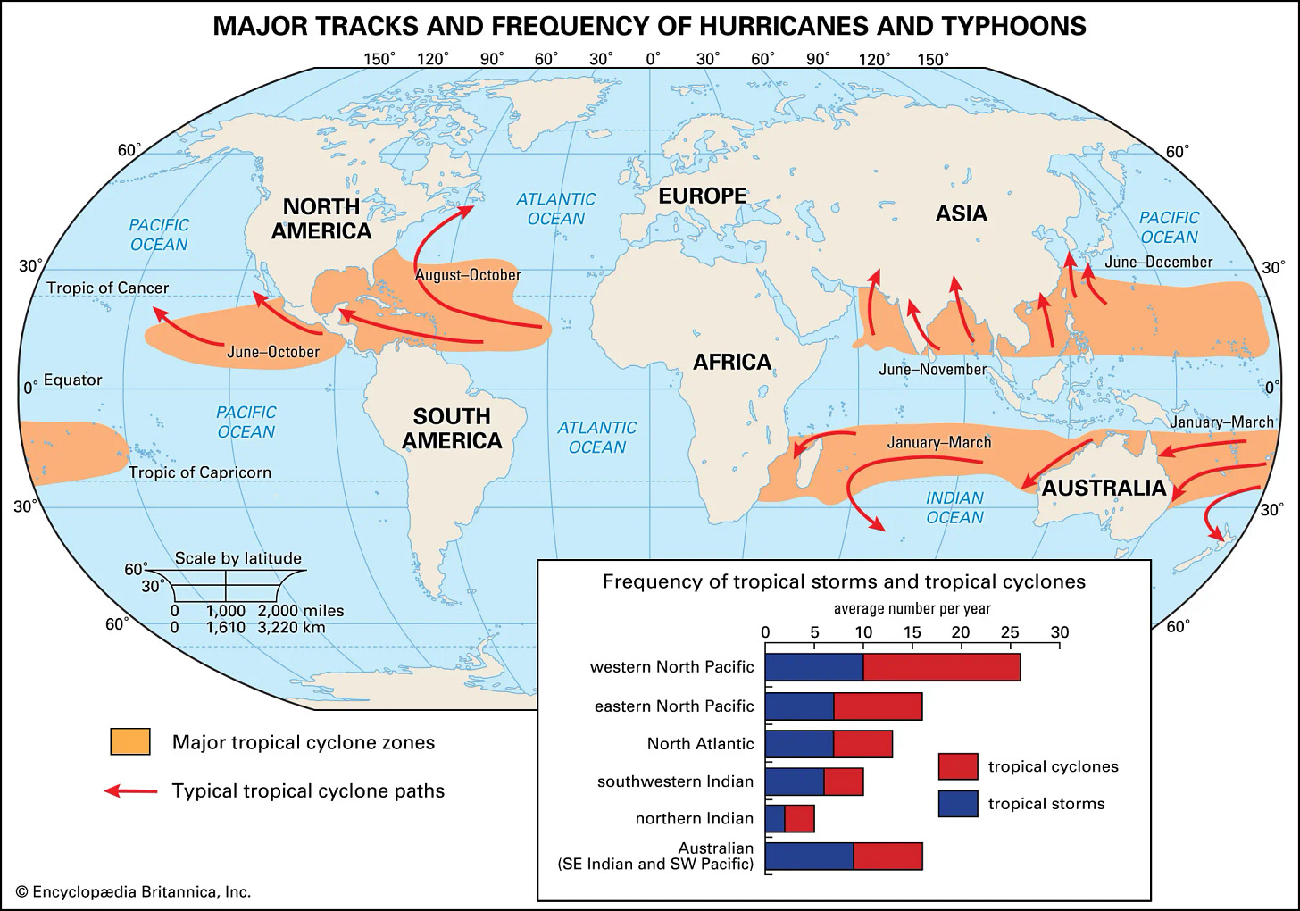
Consequently, if the underlying sea-surface temperature were unchanging, tropical cyclones would get stronger and stronger as they move to higher latitudes. The reason they tend to peter out at latitudes greater than 30 degrees is because the underlying sea surface temperature cools, eventually falling below the critical threshold of 26 C, so at present they’re confined to within the topics, as shown below.
They’re called tropical cyclones in the South Pacific, Hurricanes in the Caribbean and Typhoons in the North Pacific. But they’re all the same thing. It looks like we’ll need to change that name that we use in this part of the world, because more and more, they won’t in the future be confined to the Tropics (defined as between the topics of Cancer (23.5 N) and Capricorn (23 S).
As the planet warms, so does the ocean surface. In future, those warmer oceans will allow the storms to continue unabated to much higher latitudes, to wreak havoc on places currently largely unaffected by them. Places like New Zealand for example. Although we occasionally suffer huge damage from these beasts - the cost of Cyclone Gabrielle earlier this year is estimated at NZ$13.5 billion - by the time they get this far south they’ve always lost their full fury and have been degraded to tropical storms. That won’t always be the case in the future.
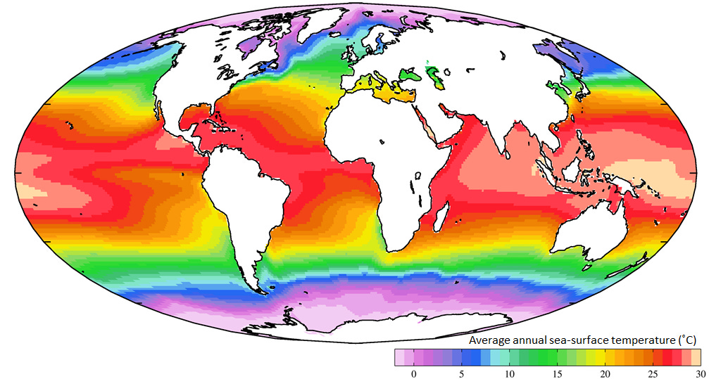
The contour map below, from here, shows current annual mean temperature of the oceans.
At mid latitudes like New Zealand’s, the ocean temperatures have a mean seasonal variation of about 8 C, so temperatures greater than the critical 26 C threshold already occur not far to the north of the country. In recent summers, anomalously high temperatures - sometimes exceeding 24 C - have already been seen in the Tasman Sea between New Zealand and Australia. In some areas the temperature there is currently increasing at the rate of more than 0.3 C per decade, so that threshold of 26 C isn’t far away in time or distance.
The penetration of tropical cyclones this to latitudes far from the equator is a question of when, not if. With those stronger Coriolis forces, when they arrive, we’ll know about it!
For most, they’ll hit home long before the threat of rising sea levels that I mentioned here a couple of weeks back.
A slight modification may be needed to Alan Jay Lerner’s “…. In Hertford, Hereford, and Hampshire, Hurricanes hardly happen”. Just an extra e and d, at the end perhaps? 😊 But perhaps not. Those English Counties are way further from the equator than any point in New Zealand (that’s the main reason why their UV is so much less and skin cancer rates are so much lower). You can see from the map above that ocean temperatures off the UK aren’t much different from off New Zealand at present, but that’s only because of the Gulf Stream brings energy from equator. In a future warmer world that flow will be much weaker.


