I was asked to write a historical note about Lauder for a Newsletter about Stratospheric Processes and their Role in Climate (SPARC, not to be confused with this or this ). Here I provide a “layman’s” version of the original, SPARC Newsletter 56, which is available here. It nicely encapsulates Lauder’s contribution to the success of the Montreal Protocol on Protection of the Ozone Layer (2900 words).
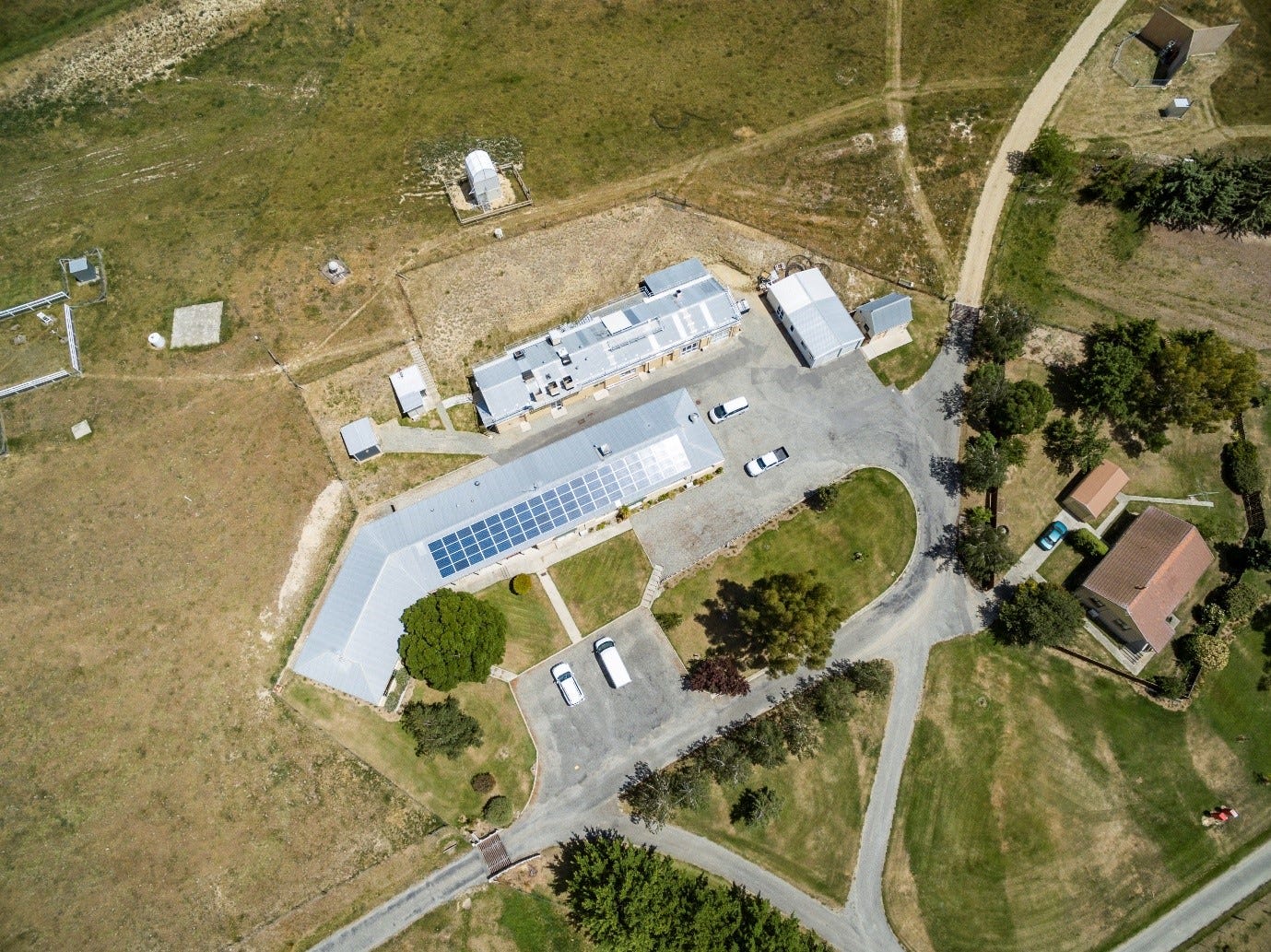
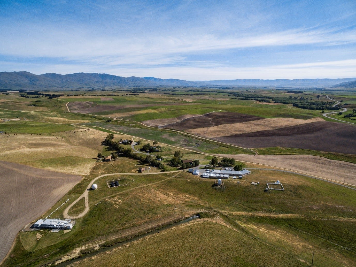
Although completely unknown to most Kiwis, Lauder is a world-famous research laboratory to the atmospheric science community. It’s located on rolling farmland in the sparsely populated backblocks of Central Otago, on the prosaically named South Island of New Zealand.
I think we can all agree that the more poetic Māori version of that name - Te Waipounamu, Aotearoa - which loosely translates to “Place of water and greenstone in the Land of the long white cloud” - evokes a whole lot more “atmosphere” 😊.
At latitude 45.04°S (and altitude 370 m above sea level), Lauder is almost exactly halfway between the equator and the south pole, in a data-sparse region of the globe. Surrounded by mountains, it’s the nearest thing New Zealand has to a continental climate. It lies in a barren semi-desert landscape within a broad river valley, bounded by high country that casts an effective rain-shadow. As a result, the annual rainfall is only 450 mm, with frequent clear skies and frosty winter nights.
The Beginnings
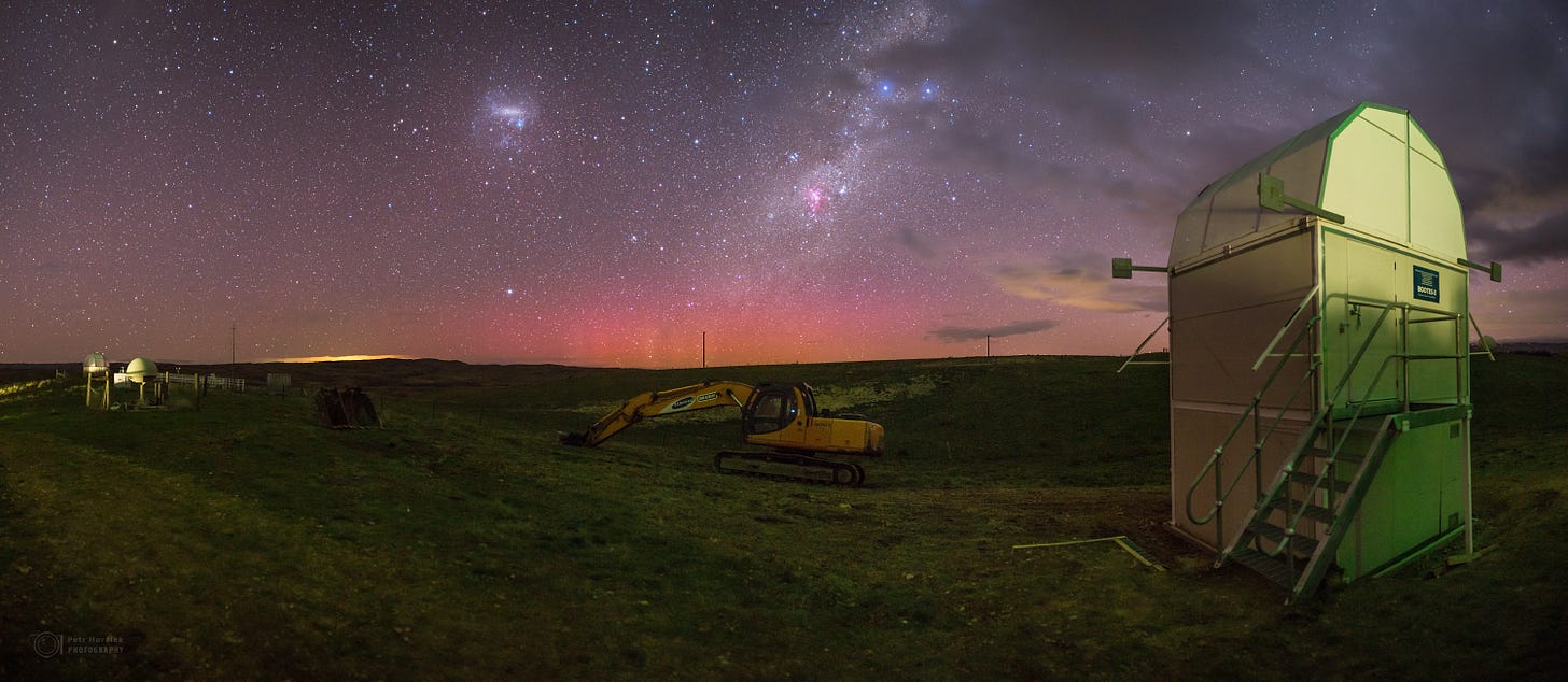
The laboratory at Lauder began its life sixty years ago as an “Auroral Station”. The location was chosen to take advantage of its clear night skies, its unobstructed views of the southern horizon, and the absence of pollution – particularly light pollution. At Lauder, the night sky can be impressively dark, with magnificent views of the Milky Way and the Magellenic Clouds (and even Zodiacal Light - according to my amateur astronomer colleague Martin Unwin, whose dad, Bob Unwin, was the boss there in the 1960s). We can put those views down to the clean air and absence of man-made light sources: just a few farmhouse lights and occasional car lights from the tiny stretches of quiet roads that aren’t obstructed by hills. The nearest town of any size is Alexandra, 40 km away. Its population then was less than 4000, now close to 6000.
The main tasks back then were measuring auroral activity from altitudes between 100 and 400 km (the “ionosphere”) to better understand and quantify its effects on compass readings and the propagation of radio communications in those pre-satellite and pre-GPS navigation days. They used radar systems to study radio aurora, and sensitive light-detectors to measure optical emissions from Aurora Australis, which is visible from land at only a few other locations outside the lower South Island of New Zealand. Changes in auroral activity (caused by changes in solar output) induce tiny variations in the electric currents that circulate high above us in the ionosphere. These in turn affect the strength and direction of the magnetic field and therefore compass readings that were a crucial navigational aid.
With the advent of satellite-borne instruments in the 1970s, Lauder’s immediate future was assured by becoming a ground station for receiving ionospheric measurement data from a Canadian series of satellites (called ISIS - not to be confused with its namesake). That’s when the original wooden huts that constituted the lab were replaced by new modern (for the time) block buildings. But another Canadian was more influential in the long-term direction and success of Lauder. That was A.W. (Tony) Harrison, from the University of Calgary.
Stratospheric research at Lauder
In January 1979, a few months before my arrival at Lauder, he brought a spectrometer to measure nitrogen dioxide (NO2) at twilight using a new measurement method pioneered by John Noxon in the USA. The technique didn’t yet have a name, but would come to be called differential optical absorption spectroscopy (or DOAS). The part of sun’s radiation spectrum used is in the blue-violet region (near wavelength 430 nm), and because of the twilight scattering geometry for these zenith-sky viewing instruments, the method is most sensitive to gases in the stratosphere about 20-30 km above the Earth’s surface – much lower than the ionosphere, but well above the “weather” sphere (troposphere) that extends up to about 10-15 km altitude. At the time, supersonic aircraft that would fly in the stratosphere were being developed, and there was concern about possible effects of their exhaust on the ozone layer because efficient chemical reactions (called catalytic cycles) involving the oxides of nitrogen were known to be capable of destroying ozone.
When I arrived at Lauder on November 12, 1979, the long-term station manager, Gordon Keys, was on sabbatical leave in Germany, and Paul Johnston (later station manager in the 1980s and 2003-2012) was the stand-in during his absence. With interest starting to wane in upper atmospheric research, Paul and I decided to branch out and extend Harrison’s work. That was the beginning of stratospheric research at Lauder. As fate would have it, that turned out to be an inspired change of direction.
By the time the Antarctic Ozone Hole was discovered in 1985, we’d already applied the method to measure the annual variability of stratospheric ozone and NO2 at Lauder: the latter showing that the column amounts there are dominated by photo-chemical reactions involving sunlight. And corresponding measurements in the lower atmosphere demonstrated the pristine characteristics of the air, with NO2 concentrations sometimes being less than 100 ppt. We’d also begun making long-term twilight measurements of these in Antarctica. In fact, our Antarctic paper on the subject was one of just seven cited in UK Scientist Joe Farman’s landmark paper signalling the discovery of the Antarctic ozone hole. It was significant because, while Farman and others suspected chlorine from CFCs was the culprit, others thought the ozone decreases were attributable to high concentrations of NO2 being modulated by the 11-year cycle in solar activity. We showed that the concentrations there were similar to those at mid-latitudes, and we later went on to show that solar activity has only a minor effect on stratospheric nitrogen dioxide. We were at the centre of an exciting new field. And the funding flowed, especially under the entrepeneurial management of Andrew Matthews, who was station manager from 1992 to 2003.
With the heightened interest in ozone and its effect on UV and human health, we went on to develop state-of-the-art UV spectrometer systems capable of detecting any changes in UV due to changes in ozone. We are still involved in the operation and maintenance of several of these at Lauder and at key locations in Australia and the USA.
Understanding the causes and effects of ozone change
In the decades that followed, the scope of measurements increased dramatically and Lauder became the prime southern hemisphere site for stratospheric research. With the help of other international groups, we began measuring a range of trace gases concerned with ozone depletion, as well as measuring ozone and its distribution with altitude using a plethora of different techniques. Some of the instruments we use to measure vertical profiles are carried aloft by balloons. Others are similar to the familiar RADARs used for navigation and traffic enforcement (RADAR is an acronym for Radio Direction and Ranging). But ours are directed upwards into the atmosphere, and use pulses of light instead of radio waves. By analogy, they’re called LIDARs (short for Light Direction and Ranging).
Since the early 1990s, Lauder staff have had leadership roles in several International Assessments (e.g., by the WMO or UNEP) that have pushed forward our understanding of ozone depletion and its consequences. These include both the Scientific Assessments of Ozone Depletion, and Assessments of the Environmental Effects of Ozone Depletion (and their interactions with Climate Change). There has also been strong involvement with the IPCC Reports on Climate Change (but only one Nobel prize winner - so far … ).
In the 1990s Lauder became the southern mid-latitude charter site in the newly established Network for the Detection of Stratospheric Change (NDSC). The scope of the Network would later be broadened to include effects of climate change, and renamed to the Network for the Detection of Atmospheric Composition Change (NDACC). Our brief had become to “understand the causes and effects of ozone change”.
We showed that in New Zealand, the overhead burden of ozone in summer is less than at comparable northern latitudes, with the amount in the troposphere being only half that in the north. Back trajectory analyses of upper air movements showed that about half of the mid-southern latitude stratospheric ozone decline in the latter part of the 20th century was from imported ozone-depleted air from Antarctica.
To resolve long term calibration issues with satellite derived retrievals of ozone, we developed tools to generate global ozone fields referenced to the ground based network, so allowing accurate trend analyses from the satellite-derived products needed for ozone assessments.
We played a leading role in specifying the instrument characteristics required to detect long term trends in UV due to ozone depletion. These were put to the test three decades later when UV spectrometers from the network were used to demonstrate the success of the Montreal Protocol in curbing increases in UV radiation. To address health concerns about ozone depletion we’d much earlier demonstrated the inverse relationship between ozone and skin-damaging UV, charted the increases in peak UV as ozone declined in the 1990s, and showed the altitude dependence of UV. We also showed how to deduce the amount of UV radiation from measurements of global short wave radiation, and applied the method to derive UV at multiple sites throughout the country. One of our most quoted results (sometimes misquoted by sunscreen advertisers) was our finding that the peak UVI at Lauder is 40 percent larger than at corresponding northern latitudes (but is still far below the global maximum).
Our measurements in Antarctica showed that special chemistry that takes place on the surfaces background aerosols is involved in the rapid removal of nitrogen in the Antarctic atmosphere in autumn (conversion of NO2 to HNO3), which is a prerequisite for efficient chlorine-induced ozone loss in the following spring, and that the rates of that chemistry were more rapid in the presence of volcanic aerosol transported from the eruption of Mt Pinatubo in 1991. Our measurements at Lauder following that eruption also demonstrated large changes associated with chemistry on the aerosol surfaces (though ozone itself was inexplicably unaffected by the aerosols over Lauder).
A new topic: climate change
With the eruption of Mount Pinatubo, Lauder’s interest and expertise expanded to include the measurement of atmospheric aerosols and clouds; and their effects on UV. The aerosol lidar time series from Lauder now covers three decades, from the Pinatubo aftermath to recent eruptions. The aerosol record also shows the intercontinental transport of seasonal biomass burning. By extending its radiation measurements, Lauder joined the international Baseline Surface Radiation Network (BSRN). Measurements from that work demonstrate that Lauder routinely has some of the cleanest air (lowest aerosol optical depths) on Earth. As well as its importance for other Lauder measurements, this showed that global dimming and brightening observed in NZ could not have been from aerosols as postulated elsewhere. It must be a cloud effect.
That broadening of scope was serendipitous because as the ozone problem now recedes, the effects of climate change – and attempts to mitigate it using climate interventions involving aerosols - have come more into focus. In addition to measuring most of the gases relevant to ozone depletion, we also now measure the main gases involved in climate change. Several greenhouse gases are measured in situ at Lauder, and a large part of the current effort involves measurements of the total column amount of these gases in the atmosphere from their absorption of solar infra-red radiation. Since 2004, data from the latter have contributed to a 3rd international network: the Total Carbon Column Observing Network (TCCON), which strives for a measurement accuracy of 0.2%. Lauder is the southernmost site in the network, and with New Zealand’s unique carbon footprint, where the warming effect from CH4 and N2O emissions from agriculture are similar to that from CO2, our measurements will have an important role to play.
Staff numbers at Lauder continued to grow through the 1980s and 1990s, a period that included a major reorganization of Science in New Zealand. Prior to April 1992 Lauder was part of the Government’s Department of Scientific and Industrial Research (DSIR), but after the reorganization it fell under the umbrella of the newly formed National Institute of Water & Atmospheric Research (NIWAR, later shortened to NIWA).
NIWA was one of initially ten Crown Research Institutes owned by the Government, but operating under their own management with an expectation that an annual dividend would be returned to the Government. Around the turn of the century staff levels at times exceeded 20 (including post-grad students), boosted largely through Greg Bodeker’s scientific leadership.

For a time there was even an in-house modelling capability at Lauder. Highlights of their work included calculating future global ozone fields that would have occurred in the World Avoided (the world that would have occurred without the success of the Montreal Protocol). Those calculations showed that UV levels at Lauder would by now already have been 20 percent more than before ozone depletion began, and that by the second half of the century, they would have increased three-fold. The modellers also produced improved simulations of ozone recovery, and recently re-assessed the impact of global warming from ozone-depleting substances.
Recent changes at Lauder
There was a major funding crisis for Lauder in 2012, when its very existence came under threat. It escaped intact only after an international outcry , but with a number of redundancies (including mine). By that time, our UV studies had moved away from pure atmospheric research more towards health effects of UV, both positive and negative.
For the first few years that followed, Lauder was only a shadow of its former self, especially after its small team of atmospheric modellers relocated to Wellington to work alongside NIWA’s new supercomputer. It’s gradually starting to rebuild, but there are now only about 10 full time staff, and new avenues of funding are always being sought. It’s now also a test site for materials degradation with the Building Research Organisation of New Zealand (BRANZ). And it has again become a ground station for satellite data – this time satellite imagery – taking advantage of its good horizon views, low noise at radio frequencies, and fast internet access. In recent years, Lauder has become a calibration centre for NIWA’s New Zealand-wide network of radiation sensors. These measurements are highly relevant in the projected move from fossil fuels to renewable energy.
In 2015, Lauder became the first southern hemisphere site for yet another international network, called GRUAN (where GRUAN is a (nested!) acronym for GCOS Reference Upper Air Network). The aim of GRUAN is to archive the highest quality vertical profiles of atmospheric temperature and relative humidity (and soon ozone) measured from balloon flights to validate satellite data and climate models.
But Lauder’s most recent acquisition has been the most profoundly different – and it’s not related to atmospheric research. It’s the deployment of a steerable 0.6 m diameter telescope designed to probe the histories of deep space to learn about the origins of our universe. It’s called the BOOTES telescope – where BOOTES stands for the Burst Observer and Optical Transient Exploring System.

The range of atmospheric measurements undertaken at Lauder is quite staggering for such a small group. The ozone lidar, which has operated in partnership with a research group from the Netherlands (RIVM) since 1994, is one of only 5 worldwide, and the only one in the southern hemisphere. Very recent data from the network showed systematic reductions in the age of air above Lauder over the last 25 years, which may have important implications for ozone recovery. The full suites of measurements required by both the NDACC and the BSRN global networks are all measured at Lauder
The prognosis for our atmosphere looks grim. We’re careering towards an uncharted regime of future climate patterns. Although it’s acknowledged that fossil fuel use must decline, there’s been little slow down so far. But Lauder is well positioned for the future. It’s the best instrumented site in the Southern Hemisphere- and arguably the world - for middle atmospheric research. Its pristine air and clear skies are added bonuses. We already have the capability of measuring any gas of interest (and extending those back in time for decades). And most of the climate interventions being considered will have potential effects on many of the parameters already being measured at Lauder.
For a more detailed and personalised account of the Lauder story over the last 40 years, please read my book “Saving our Skins”. It’s available from Amazon in colour (best but expensive), black and white (cheaper), and pdf (cheapest, with hyperlinks).
Thanks for listening. For more occasional free posts on the intersection of UV, Health and Climate Change, please click below


